New System to Be Deployed off Nag’s Head
Water covers about 71% of the Earth’s surface, and our oceans hold about 96.5% of it. It’s no surprise then that oceans play a key role in the Earth’s weather, climate and food supply.
So, it’s important to know what’s happening in the ocean. And the ocean off North Carolina’s coast is going to get a closer look starting in 2024.
That’s when a set of scientific instruments, called the Coastal Pioneer Array, will be deployed about 35 miles off Nags Head. The system is part of the Ocean Observatories Initiative, or OOI.
“The OOI offers many opportunities for scientists to obtain data to further their research, and it provides insight into conditions in the area for a variety of stakeholders,” said Dr. Albert Plueddemann, project scientist for OOI’s Coastal Global Scale Nodes group at Woods Hole Oceanographic Institution. “We welcome researchers, educators and industry members to reach out to us to explore ways we might work together to maximize the usefulness of the data.”
What Is the Ocean Observatories Initiative?
The Ocean Observatories Initiative is a science-driven ocean observing network that delivers real-time data from more than 900 instruments. The Woods Hole Oceanographic Institution, an independent nonprofit dedicated to ocean research, exploration and education and based in Massachusetts, runs the OOI.
Five arrays are currently deployed. One is near the tip of Greenland, and three are in the Pacific Ocean off the United States and Canadian coast. The fifth will be redeployed from Martha’s Vineyard to the coast of North Carolina, off Nag’s Head.
The location off the NC coast is called the Mid-Atlantic Bight, which runs from Massachusetts to North Carolina. A bight is a concave bend or curvature in a coastline or river. It can also refer to a very open bay formed by such a feature.
Two other arrays, one in the South Pacific and the other in the South Atlantic, were discontinued.
The project is funded by the National Science Foundation.
Ocean Data for Everyone
The initiative’s website says the data collected by observing the ocean can help track, predict, manage and adapt to changes in the marine environment. Coastal communities can use the data to prepare for floods and other natural disasters.
While the data is primarily used by scientists, the information is available to anyone with an Internet connection.
“We have users ranging from high school students to commercial fishers,” said Dr. Plueddemann.
How the Ocean Is Monitored
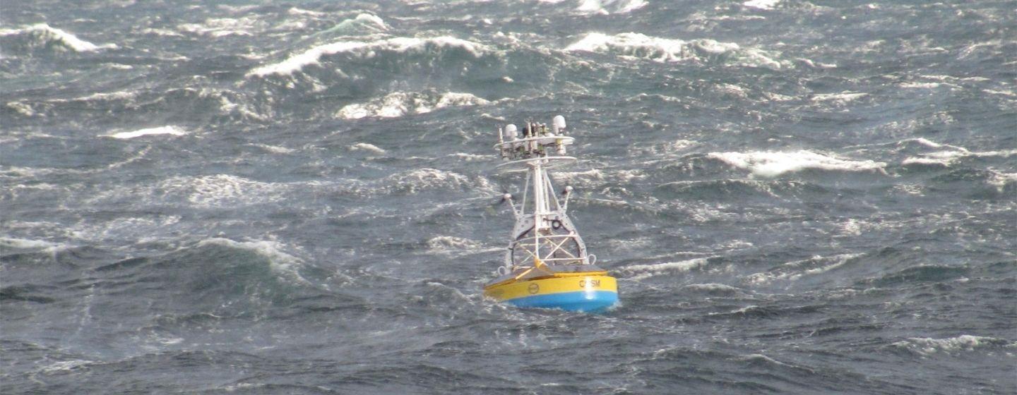
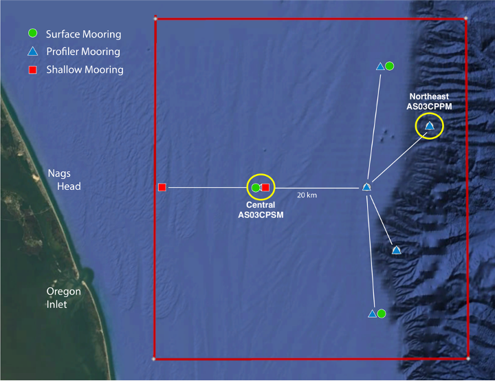
The OOI’s Coastal Pioneer Array is made up of ten moorings of scientific instruments at seven different sites. They will all be located at the edge of the continental shelf, where the ocean drops from 200 meters (656 feet) to more than 2,000 meters (6,561 feet).
A surface mooring designed to examine coastal-scale phenomena and withstand the challenging conditions of shallow coastal environments will be deployed at 30 meters (98 feet) deep.
A coastal profiler mooring will be deployed at 600 meters (1,968 feet) deep.
Both profilers utilize a long wire that moves through the water column, continuously sampling ocean characteristics from about 75 feet below the surface to 75 feet above the sea floor.
“The combined moorings work together to observe different space and time scales,” Plueddemann explained. “The Mid-Atlantic Bight off the Outer Banks is an important region with a vibrant ecosystem. We hope to learn about Gulf Stream influences, land-sea interactions associated with large estuarine systems, the status of a highly productive ecosystem with major fisheries and fresh-water outflows during extreme rain events.”
The Coastal Pioneer Array was deployed off New England in 2016. Researchers always planned to move the instruments after about 5 years, but the COVID-19 pandemic pushed the timeline.
Dr. Reide Corbett, executive director of East Carolina University’s Coastal Studies Institute in Wanchese, believes the new deployment of the array will draw the interest of scientists around the world.
“There is so much happening off our coast, including a vibrant fishing industry and offshore wind development, not to mention hurricanes,” said Corbett. “This is a region of complex physics and critical ecosystem dynamics that draw interest from many disciplines, and the OOI should improve our understanding of our coast.”
The array will be deployed in early 2024.